Guide to Integrating TrackAsia Maps into Your Website or Application

TrackAsia Map provides powerful map tools that make it easy to integrate maps into your website or application. Below is a detailed step-by-step guide:


1. Register an account


              – Visit the official TrackAsia Map website.

               – Click the “Register” button or here and fill in all the required personal information.

               – After successful registration, you will receive an account activation email. Check your inbox and click the activation link.


2. Activate your account


              – After activation, you can log into the system.

              – TrackAsia currently has a promotion: free 100,000 VND when creating a new account. (Note: The program may change from time to time.)


3. Create and manage Key


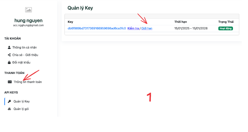
             – Access the Key Management section in the dashboard.

             – Click the Create Key button to create your own API key.

             – Check the number of queries used in the Package Management section.


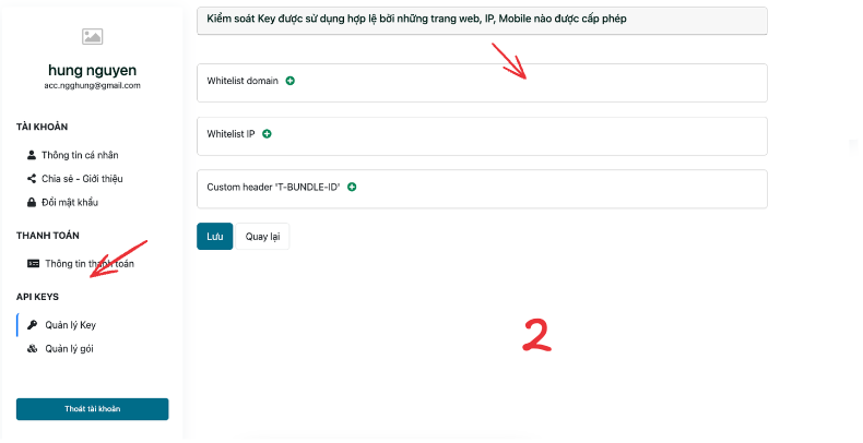
4. Secure your Key


          To ensure safety, you can set query limits in the Limits section. Security options include:

           – Whitelist domain: Only allow specific domains to use the key.

           – Whitelist IP: Only allow specified IP addresses to use the key.

           – Custom header ‘T-BUNDLE-ID’: Define custom header information to control key usage.
image

image

5. Manage packages          
 

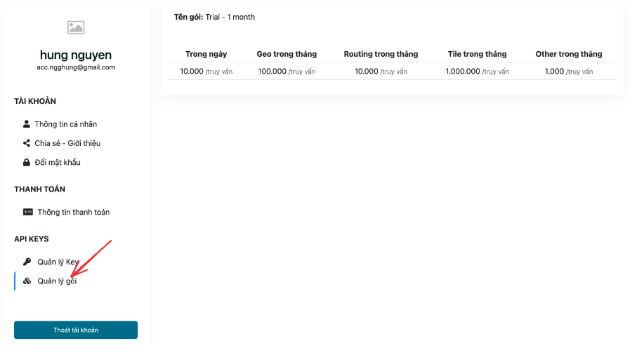
     From the API KEYS section, you can access Package Management to monitor and manage your query limits. Specifically from the example below:

          – Daily: The maximum number of queries you can use per day for each service.

          – Geo per month: The maximum number of geographic queries per month (100,000 queries).

          – Routing per month: The maximum number of routing queries per month (10,000 queries).

          – Tile per month: The maximum number of map queries per month (1,000,000 queries).

          – Other per month: Other queries (1,000 queries).

Each section limits the number of queries you can perform per month or day for each service.          
 

image

6. Integrate TrackAsia Map into your website or application


          Visit the Related Documentation page for detailed information:

              – API parameters.

              – API link.

              – Specific examples of usage.


When integrating:


     1. Replace the public key with your own key.          

          Note: The public key is a demo key, limited in queries and only for testing.          
 

      2. Use the provided examples to quickly deploy.          
 

Initial URL:


https://maps.track-asia.com/api/v2/geocode/json?address=Landmark 81&size=1&key=public_key

URL after replacing the key:


https://maps.track-asia.com/api/v2/geocode/json?address=Landmark 81&size=1&key=db6f989bd7317369166959698ad6ca3fc0


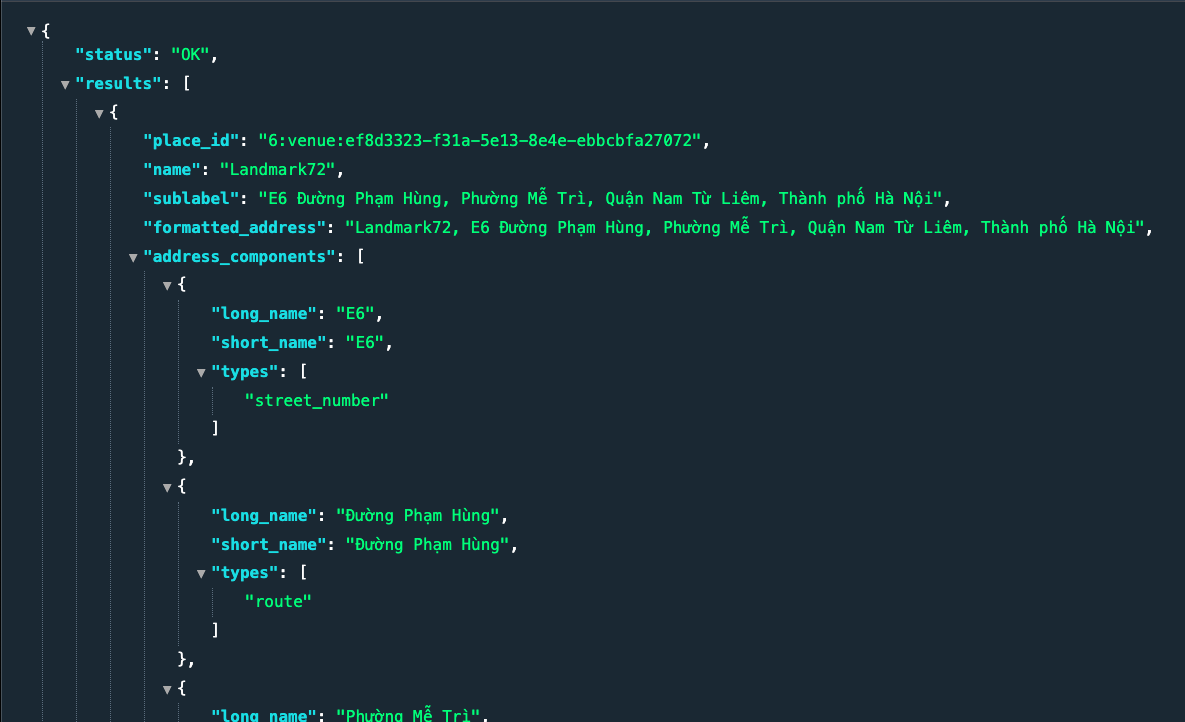
Result:  

image          
Important note:          
 

           – Only use your own key for actual deployment.

           – The public key is only suitable for initial testing.

7. Documentation and support          
 

         If you need more detailed information, you can refer to:

             Related Documentation

              – Source code repository on GitHub.

              – Sample application examples for mobile devices:

                     – Android

                     – iOS

With just a few simple steps, you can effectively and safely integrate TrackAsia Map into your project. If you encounter difficulties, do not hesitate to contact the support team for timely assistance.
The Role of Digital Maps in the Digital Transformation of Vietnam’s Logistics Service Industry

Vietnam’s logistics service industry is undergoing a rapid digital transformation,
driven by the increasing adoption of digital technologies such as artificial intelligence,
big data, and the Internet of Things (IoT). Digital maps are playing a crucial role in
this transformation by providing logistics service providers with the data and
insights they need to improve efficiency, optimize operations, and deliver better
customer service.

Digital maps are being used by logistics service providers in Vietnam to:

● Plan and optimize delivery routes: Digital maps can
be used to identify the shortest and most efficient routes between delivery points,
taking into account factors such as traffic congestion, road conditions, and
weather. This can help logistics service providers save time and fuel, while also
reducing their carbon emissions.

● Track shipments in real-time: Digital maps can be used to
track shipments in real-time, providing logistics service providers with
visibility of their goods’ location at all times. This can help improve customer
satisfaction by providing customers with updated delivery estimates.

● Manage warehouse operations: Digital maps can be used to manage warehouse
operations, such as optimizing inventory locations and tracking the movement of goods.
This can help improve warehouse efficiency and reduce costs.

● Provide customer service: Digital maps can be used to provide
customer service, such as giving customers real-time delivery updates and allowing
them to track their shipments online. This can help improve customer satisfaction
and loyalty.

Benefits of digital maps in the logistics industry

The use of digital maps is bringing several benefits to the logistics service industry in Vietnam, including:

● Increased efficiency: Digital maps can help logistics service providers enhance
efficiency by optimizing routes, tracking shipments in real-time, and
managing warehouse operations.

● Cost reduction: Digital maps can help logistics service providers reduce
costs by saving time and fuel, while also reducing the need for manual data
entry.

● Improved customer service: Digital maps can help logistics service
providers improve their customer service by providing customers with updated
delivery estimates and allowing them to track their shipments online.

The future of digital maps in the logistics industry

The use of digital maps in the logistics service industry will only grow in
the future. As digital technologies continue to evolve, we can expect
to see even more innovative applications of digital maps in the logistics industry. For example,
we may see the development of self-driving trucks using digital maps to navigate
their routes. We may also see the development of drones using digital maps to deliver goods to remote
locations.

Track-Asia and Vietnam’s logistics industry:

Recognizing the role of digital maps in the digital transformation of Vietnam’s logistics industry
as mentioned in the sections above, the Track-Asia digital map platform was created to meet
the needs of applying information technology suitable for the characteristics of each Vietnamese transport enterprise.

Features of Track-Asia:

⦁ Geocoding: converts geocoded addresses to national addresses and converts national
addresses to geocoded addresses that users can understand.

⦁ Distance Matrix: mapping and routing application to calculate time, distance,
and routes for multiple transport vehicles.

⦁ Autocomplete: search function combined with automatic suggestions to help
users find accurate and relevant locations.

⦁ Map view: detailed and optimized map display according to transmission. Compatible with all
different types of devices such as Web/Mobile.

⦁ Routing: navigation and mapping refer to the process of determining the best or
optimal route between two or more locations.

⦁ Mobile SDK: SDK simplifies the development process by providing built-in functions
that can be easily integrated into applications quickly.

From the above features of Track-Asia, logistics companies can integrate into
their app or website to perform the following transport monitoring features:


❖ Helps businesses and customers easily manage and monitor order routes.

❖ Monitor order status and driver location visually on the map through
the system and app

❖ Monitoring system, notifying the actual transport status if there are any issues including:
driver change, vehicle change, sub-route change, route reversal, etc.

The Application of TrackAsia Digital Maps for Agricultural Businesses

Are you running an agricultural business and wondering how digital maps can benefit you? In reality, digital maps are no longer an unfamiliar concept but have become an essential tool for optimizing operations, enhancing competitiveness, and ensuring sustainable development in the agricultural sector. From farm management to supply chain tracking, digital maps open up new opportunities, helping agricultural businesses achieve remarkable success.

If you are looking for an effective and practical digital mapping solution tailored for agricultural businesses, this article is for you! Let’s explore the real-world applications of TrackAsia, a powerful tool that can help your business thrive.


Digital Maps – “A Powerful Assistant” for Agricultural Businesses


Before diving into the specific applications of TrackAsia, let’s take a closer look at the role of digital maps in the operations of agricultural businesses today:

  • Optimizing Production Processes: Digital maps assist businesses in managing farms, tracking crop seasons, optimizing production processes, reducing costs, and increasing productivity.


  • Supply Chain Management: Digital maps help businesses oversee their supply chain from farms to factories and stores, ensuring food quality and safety.


  • Market Expansion: Digital maps support businesses in reaching new markets, finding partners and customers, and expanding distribution channels.


  • Data Analysis: Digital maps provide analytical tools that help businesses gain insights into the market, customers, and competitors, enabling informed decision-making.


  • Improved Management Efficiency: Digital maps assist in managing assets, vehicles, and staff, ensuring safety and efficiency in operations.


  • Enhanced Competitiveness: By adopting advanced mapping technology, businesses can differentiate themselves from competitors, attract customers, and increase revenue.


TrackAsia – A Custom-Tailored Digital Mapping Solution for Agriculture


TrackAsia not only provides an accurate and detailed mapping system but also offers specialized features and tools designed specifically for agricultural businesses. How can TrackAsia be applied in practice?

1. Application in Farm Management


  • Cultivation Area Management: TrackAsia helps businesses oversee farmland and livestock areas, monitor soil conditions, crops, and livestock.
  • Production Planning: The platform assists in planning production, from selecting crop types and livestock to scheduling planting and harvesting.
  • Resource Management: TrackAsia helps businesses manage resources such as water, fertilizers, and pesticides efficiently, reducing costs.
  • Weather Monitoring: Integrated weather information enables businesses to proactively prevent natural disasters and diseases.


2. Application in Supply Chain Management

  • Agricultural Product Tracking: TrackAsia allows businesses to track agricultural products during transportation, ensuring quality and food safety.
  • Warehouse Management: The platform helps monitor inventory levels and product quality, allowing for strategic storage and distribution planning.
  • Partner Connectivity: TrackAsia facilitates connections with partners, factories, and retailers, expanding distribution channels.


3. Application in Data Analysis

  • Market Analysis: TrackAsia supports businesses in analyzing market demand and agricultural product pricing, enabling well-informed business decisions.
  • Production Efficiency Analysis: The platform helps businesses assess production efficiency, identify factors affecting yield and quality, and implement improvements.
  • Risk Analysis: TrackAsia aids in analyzing risks such as natural disasters, diseases, and market fluctuations, enabling businesses to develop preventive and responsive strategies.


4. Application in Marketing and Sales

  • Customer Engagement: TrackAsia allows businesses to reach potential customers through online maps, promoting products and services.
  • Interactive Mapping: The platform enables businesses to create interactive maps where customers can search for information, place orders, or contact the business effortlessly.


Practical Benefits of Using TrackAsia for Agricultural Businesses


Utilizing TrackAsia not only optimizes business operations but also brings significant benefits:

  • Increased Productivity and Quality: Digital maps enable scientific farm management and optimized production processes, enhancing agricultural yield and product quality.
  • Cost Reduction: Businesses can cut expenses on fertilizers, pesticides, irrigation, and transportation, improving profitability.
  • Optimized Supply Chain: Efficient supply chain management ensures product quality and food safety.
  • Market Expansion: Businesses can access new markets, find partners, and expand distribution channels.
  • Enhanced Management Efficiency: Digital maps improve asset, vehicle, and workforce management, ensuring operational safety and effectiveness.
  • Strengthened Competitiveness: Advanced digital mapping technology helps businesses stand out from competitors, attract customers, and boost revenue.
  • Sustainable Development: Digital maps enable data-driven decision-making, promoting sustainable agricultural growth.
  • User-Friendly Interface: TrackAsia is designed with a simple and intuitive interface, making it accessible to both tech-savvy and non-technical users.


Digital maps have become an indispensable tool for agricultural businesses. TrackAsia offers a specialized digital mapping solution that helps businesses optimize operations, strengthen competitiveness, and achieve sustainable growth.

Contact us today to explore the potential of digital maps in agriculture!

Massive Offers from TrackAsia: Sign Up Now to Receive Thousands of Rewards!

Are you looking for an optimal, cost-effective digital map solution that still ensures efficiency? Do you want to experience a digital map platform highly rated by experts and customers? 

Don’t miss this “once-in-a-lifetime” opportunity! TrackAsia officially launches a “huge” promotion program in 2025, exclusively for new customers and those using other map platforms who want to switch to TrackAsia.

TrackAsia – The leading digital map solution in Vietnam:

TrackAsia is a digital map platform developed by a team of experienced experts, with advanced technology and accurate, continuously updated data. We provide comprehensive digital map solutions to meet all business needs, from logistics, retail to agriculture and many other fields.


Special promotion program:

To thank our customers and offer the opportunity to experience TrackAsia at the best cost, we introduce the following two attractive promotion programs:

1.  Offers for new customers: 
 

  • Pay As You Go Package: Get $50 credited to your account when you register for the Pay As You Go service.
  • Subscription Package: Get $200 credited to your account when you register for Subscription service packages.  

*Note: Offers apply to each new registered customer, not duplicated email/phone number.


2.  Offers for customers switching from other platforms: 
 

  • Pay As You Go Package: Get $100 credited to your account when you register for the Pay As You Go service.
  • Subscription Package: Get $300 credited to your account when you register for Subscription service packages.

*Note: Offers apply to each new registered customer, not duplicated email/phone number. 
 

❖Application period: 

The promotion program starts from 01/01/2025 to the end of 30/12/2025.


❖Terms and conditions:

  • Customers will only receive the promotional credit code after being consulted by Sales and confirming the correct registered information.
  • Offers apply to customers nationwide.

Why should you choose TrackAsia?


  • Cost savings: With flexible service packages and attractive promotions, TrackAsia helps you save on digital map costs optimally.
  • Superior efficiency: TrackAsia provides accurate, continuously updated map data, helping you optimize business operations and improve operational efficiency.
  • Easy to use: With a user-friendly interface, TrackAsia is suitable for all users, requiring no IT expertise.
  • Dedicated support: TrackAsia’s support team is always ready to answer any questions and assist you during the service use process.
  • Diverse options: TrackAsia offers various service packages to meet all business needs, from small to large enterprises.


Are you ready to experience the difference of TrackAsia? 

Register today to not miss the special offers from TrackAsia!

Click the link: https://account.track-asia.com/  to register an account and receive the offer immediately! 

Don’t miss the opportunity to experience the leading digital map solution in Vietnam at the most favorable cost! Register TrackAsia today to receive attractive offers and explore new potentials for your business! 
 

Ho Chi Minh City Renames Several National Highways: Update Now for Accurate Transport Planning

Ho Chi Minh City has just decided to rename a series of national highways passing through the area, causing considerable disruption for residents and transport businesses. Updating information about these changes is extremely important to ensure smooth and accurate travel and transportation of goods. TrackAsia provides readers with detailed information about this change, while emphasizing the importance of using digital maps to always keep up with the latest changes.

According to the latest decision of the People’s Committee of Ho Chi Minh City, many national highways passing through the city have been renamed, specifically as follows:

  • National Highway 1 (section through Ho Chi Minh City) is divided into 3 sections:       
    – Section 1 from Thu Duc intersection (old Tram 2 junction) to An Suong intersection is named Do Muoi       
    – Section 2 from An Suong to An Lac, over 14 km long, is named Le Duc Anh       
    – Section 3 from An Lac to the Long An provincial border, 9.4 km long, is named Le Kha Phieu.       
     
  • National Highway 1K: over 1.8 km through the city is renamed Hoang Cam.       
     
  • National Highway 22 is divided into 2 sections:       
    – Section 1 from the National Highway 1 intersection to An Ha bridge, 10 km long, is named Le Quang Dao       
    – Section 2 from An Ha bridge to the Tay Ninh provincial border, 20 km long, is newly named Phan Van Khai       
     
  • National Highway 50, 8.5 km from Nguyen Van Linh road to the Long An provincial border, is newly named Van Tien Dung.       
     

Renaming these national highways may cause certain difficulties for residents and transport businesses in finding routes, planning travel, especially for those who do not frequently travel on these roads.      
  

Read the original article at here 


For transport businesses, renaming these national highways can have significant impacts, including:


  • Difficulty in route planning: Transport businesses need to update information about new road names to plan transportation routes accurately and efficiently.       
     
  • Risk of wrong delivery location: Not knowing the new road names can lead to wrong delivery locations, causing time loss, costs, and affecting the company’s reputation.       
     
  • Time-consuming route finding: Drivers may spend extra time finding routes due to unfamiliarity with new road names, especially during peak hours.       
     
  • Impact on operational efficiency: These difficulties can affect the operational efficiency of businesses, causing time and cost waste and reducing productivity.       
     

To help transport businesses overcome these difficulties, TrackAsia provides a comprehensive digital map solution with the following superior features:


  • Continuously updated map data: TrackAsia always updates the latest map data, including information about road names, locations, and traffic, helping businesses keep up with the latest changes.


  • Smart route finding: TrackAsia provides a smart route finding tool, helping drivers find the optimal route, saving time and fuel.


  • Vehicle tracking: TrackAsia allows businesses to track vehicle locations in real-time, ensuring safety and efficiency during transportation.


  • Easy integration: TrackAsia can be easily integrated into existing transport management systems of businesses, helping you manage operations effectively.       
     

Renaming national highways is a major change, requiring transport businesses to be prepared and respond promptly. TrackAsia will be a reliable companion, helping you overcome these difficulties and improve operational efficiency.       
Visit TrackAsia’s website today to learn more about the digital map solution for transport businesses and experience our superior features.       
 

TrackAsia: Cost-Effective and Seamlessly Integrated Solutions for Your Business

When it comes to digital mapping solutions, cost-efficiency and seamless integration are often top priorities for businesses and developers. TrackAsia addresses both aspects, offering a robust yet economical mapping platform designed to meet the needs of enterprises and developers alike.

Why Choose TrackAsia?


1. Cost-Effective Solutions for Every Budget

TrackAsia understands that businesses require solutions tailored to their financial plans. With flexible payment options, you have the freedom to choose a plan that meets your needs:

  • Pay-As-You-Go Plan: An ideal option for businesses or developers seeking flexibility to scale usage up or down without long-term commitments.
  • Subscription Plan: Perfect for frequent users with a fixed monthly cost. This flexibility ensures that whether you’re a small business or a large enterprise, TrackAsia can provide a solution that fits your budget.


2. Easily Integrates with Business Systems

Complex integrations are a thing of the past with TrackAsia. Designed for simplicity, its user-friendly APIs make adding mapping functionalities to your application or system effortless. Whether you’re an experienced developer or a business owner new to digital maps, TrackAsia offers:

  • Developer-Friendly APIs: Optimized documentation and tools to save time and effort.
  • Compatibility: Easy integration with existing enterprise systems, minimizing downtime and deployment-related costs.


3. Customizable for Coding/Development and Business Needs

From startups to large corporations, TrackAsia is built with flexibility and performance in mind. Its extensive feature set supports a variety of use cases, including logistics, route optimization, and location-based service applications. Developers will appreciate its powerful and intuitive platform, while businesses can rely on its scalability to grow alongside their operations.


What Sets TrackAsia Apart?

  • Cost Optimization: Budget-friendly plans deliver high-quality mapping solutions without breaking the bank.
  • Ease of Use: Simple integration saves time and reduces complexity.
  • Scalability: Designed to grow with your business, supporting small-scale projects to enterprise-level deployments.


Ready to Transform Your Business?

Discover how TrackAsia can help your business save costs while seamlessly integrating powerful mapping solutions into your operations.

Learn more about how TrackAsia offers both economical and easy-to-integrate solutions for your business!
Visit TrackAsia’s website today and explore its full range of features.

The Benefits of Using TrackAsia Digital Maps

In today’s fast-paced world, digital maps have become essential tools for both businesses and individuals. Among the leading providers of digital mapping services is TrackAsia, a platform offering advanced solutions tailored to modern needs. Let’s explore the benefits of digital maps with TrackAsia and why they are revolutionizing the way businesses operate.

What Are Digital Maps?

Simply put, digital maps are modern, interactive tools that help users visualize and navigate geographic locations on devices like smartphones, computers, or even vehicles. Unlike traditional paper maps, they provide dynamic features such as live navigation, geocoding, and real-time updates.
TrackAsia’s digital maps take this technology to the next level by offering advanced features specifically designed for businesses and professional use.

Benefits of Using TrackAsia Digital Maps


1. High Accuracy and Real-Time Updates

TrackAsia ensures that its digital maps are always up to date, providing accurate details of streets, landmarks, and boundaries. This accuracy is vital for businesses that rely on timely and precise navigation, such as logistics or delivery companies.

2. Flexible Navigation for Businesses

Navigating unfamiliar areas has never been easier. TrackAsia digital maps come equipped with intelligent routing capabilities, guiding users to their destinations through the most efficient routes. This is particularly beneficial for businesses in transportation and logistics, where time and efficiency are critical.

3. Customizable Solutions for Diverse Business Needs

TrackAsia isn’t just a one-size-fits-all tool. It offers digital mapping services tailored to various industries, from e-commerce and retail to urban planning and fleet management. Businesses can leverage these maps to optimize operations, track assets, and enhance customer satisfaction.

4. Advanced Features for Modern Enterprises

TrackAsia provides features that go beyond simple navigation, including:

  • Geocoding: Converts addresses into geographic coordinates, making it easier for businesses to pinpoint exact locations.
  • Static Maps: Creates visually appealing maps for presentations, websites, or reports.
  • Distance Matrix: Calculates travel time and distances between multiple locations, ideal for delivery planning.
  • Routing and Autocomplete: Simplifies trip planning and enhances user experience with intelligent suggestions.


5. Cost Efficiency and Scalability

For businesses, cost efficiency is key. TrackAsia offers scalable solutions that cater to your needs, ensuring you only pay for what you use. Whether you’re a small startup or a large corporation, these maps provide significant value without overburdening your budget.


6. Sustainability and Innovation

Digital maps like those provided by TrackAsia promote eco-friendly practices by helping businesses reduce fuel consumption through optimized routes. This not only cuts costs but also contributes to a greener planet.

Why Choose TrackAsia for Your Digital Mapping Needs?

TrackAsia digital maps stand out for their user-friendly interface, advanced features, and commitment to innovation. Whether you’re a business owner seeking to optimize logistics or an individual in need of reliable navigation, TrackAsia delivers solutions tailored to your requirements.

By harnessing the power of TrackAsia’s digital mapping services, you’re not just using a tool; you’re embracing a transformative technology that reshapes how you operate, connect, and grow.
The benefits of digital maps are undeniable, and with providers like TrackAsia, these advantages are more accessible than ever. From improving navigation to enhancing business efficiency, TrackAsia digital maps are changing the game in the world of location-based services.

Start your journey with TrackAsia today and experience the difference digital maps can make!

Introduction to TrackAsia Digital Maps and Key Features

1. Static Maps


The Static Maps feature delivers high-resolution, static map images, ideal for integration into reports, websites, and mobile applications. TrackAsia’s maps offer precise geospatial data, including accurate locations, routes, and specific areas, making them perfect for professional presentations and visual storytelling.

2. Geocoding


Geocoding is an indispensable tool that converts addresses into geographic coordinates (latitude and longitude) or vice versa. This feature is crucial for businesses needing accurate and timely logistics management or customer location services.

3. Autocomplete


The Autocomplete feature streamlines the search process by providing predictive location suggestions. As users type keywords, the system dynamically suggests relevant addresses and landmarks, significantly reducing input errors and saving time.

4. Routing


The Routing feature identifies optimal routes between designated points while accounting for variables such as real-time traffic conditions, vehicle types, and route restrictions. This functionality is invaluable for transport and logistics operations aiming to improve efficiency.

5. Distance Matrix


The Distance Matrix provides comprehensive data on distances and estimated travel times between multiple locations. This feature serves as the foundation for strategic transport planning, route optimization, and cost-saving initiatives for businesses.

6. Vehicle Routing Problem (VRP)


The VRP module addresses complex vehicle routing optimization by considering parameters such as load capacity, delivery time windows, and fleet size. It is an excellent tool for logistics companies looking to refine their operational strategies.

7. GEO-TOOL


GEO-TOOL is an advanced geospatial data analysis suite that allows users to customize and manipulate maps to meet specific requirements. It supports features like area demarcation, distance calculations, and impact zone analysis, empowering data-driven decision-making for businesses.

Why Choose TrackAsia?
TrackAsia is more than just a digital mapping platform; it’s a critical tool for businesses to optimize operations and gain a competitive edge. With standout features like Static Maps, Geocoding, Autocomplete, Routing, Distance Matrix, VRP, and GEO-TOOL, TrackAsia provides comprehensive solutions to enhance business efficiency.

Discover how TrackAsia can support your business by visiting TrackAsia.vn today!
———————————————-

TRACK-ASIA DIGITAL API MAP
🏢 Address: Billion Ways Building, 15A Võ Văn Kiệt, Ward 16, District 8, Ho Chi Minh City
📞 Phone: 093.182.4182 / 0906.753.438 / +84.0816510073
📧 Email: [email protected]
🌐 Website: https://track-asia.com/
#apimapsolution #TrackAsia #BusinessMapping #digitalapimap

Digital Maps Are Transforming the Real Estate Market

Digital maps are transforming the real estate market in many ways. They have also become an indispensable tool for real estate professionals as well as consumers. In this article, we will explore how digital maps are changing the real estate market.

I. Enhanced Access to Information

Digital maps provide potential buyers and renters with extensive information about properties, including:

● Location
● Size
● Price
● Features
● Amenities
● School districts
● Crime rates

This information can be easily filtered and sorted to help users find properties that meet their specific needs.

II. Improved Property Visualization

Digital maps allow potential buyers and renters to view properties from various perspectives, including:

❖ Street view
❖ Aerial view
❖ 3D view

These virtual tours help buyers and renters gain a better understanding of the property before visiting in person.

III. Streamlined Property Search

Digital maps allow users to search for properties based on various criteria, such as:

➢ Location
➢ Price
➢ Size
➢ Number of bedrooms
➢ Number of bathrooms
➢ School districts
➢ Crime rates

This helps users narrow down their search and find properties that suit their needs.

IV. Enhanced Communication Between Agents and Clients

Digital maps can be used to share information between real estate agents and their clients. For example, agents can use maps to:

★ Show clients properties that meet their needs
★ Highlight the best features of a property
★ Help clients visualize commuting from a property to their workplace or school

V. Increased Transparency in the Real Estate Market

Digital maps can help increase transparency in the real estate market by giving potential buyers and renters access to a wealth of property information. This can level the playing field and ensure that everyone has access to the information they need to make informed decisions.

VI. New Opportunities for Real Estate Professionals

Digital maps are creating new opportunities for real estate professionals. For example, agents can use maps to:

● Target their marketing efforts to specific neighborhoods
● Create virtual tours of properties
● Track clients’ search progress

VII. Track-Asia Digital Maps and the Real Estate Industry:

The Track-Asia digital mapping platform offers features that meet the real estate industry’s needs. Our features include:

❖ Geocoding: converting geo-coded addresses into national addresses and converting national addresses into geo-coded addresses that users can understand.
❖ Distance Matrix: a mapping and routing application that calculates time, distance, and routes for various transportation modes.

Digital Map Trends 2025: Shaping the Future of Businesses

In the digital era, maps are no longer just tools for navigation. Digital maps have become an indispensable part of daily life and business operations. From location search, ride-hailing, and delivery services to supply chain management, digital maps play a crucial role in streamlining processes and enhancing user experiences.

With the continuous advancement of technology, digital maps are undergoing significant transformations. The year 2025 promises a surge of new trends that will redefine how we interact with maps and apply them in practice. Keeping pace with these trends not only helps businesses stay relevant but also unlocks tremendous growth opportunities.

What are the most noteworthy digital map trends for 2025? Let’s explore them in detail with TrackAsia:


1. 3D Digital Maps and Virtual Reality (VR/AR): Unlocking New Spatial Experiences


Traditional 2D maps are familiar to most users, but 3D maps and VR/AR are heralding a new era of spatial experience. Instead of merely viewing flat lines and symbols, users can immerse themselves in vibrant 3D spaces, interacting with virtual objects in a realistic manner.

The applications of 3D map and VR/AR technology are vast, including:

  • Tourism: Tourists can explore famous destinations realistically before visiting them. Virtual tours are gaining popularity, enabling remote exploration of various locations.
  • Real Estate: Homebuyers can virtually tour apartments and villas in detail through 3D maps and VR, facilitating quicker and more informed decisions.
  • Logistics: Companies can use 3D maps to simulate warehouses, optimize goods arrangement, and manage storage space efficiently.
  • Education: Students can explore historical monuments and iconic architectural works via 3D maps and VR, gaining knowledge in an engaging, visual way.

As these technologies become more widespread, they will offer innovative spatial experiences and applications across industries.


2. Digital Maps Based on AI:Optimizing Every Process


Artificial Intelligence (AI) is becoming the main driving force in digital map development, with the ability to process vast amounts of data, analyze information, and make accurate predictions.

Applications of AI in digital maps:

  • Route Optimization: AI can analyze traffic, weather, and road conditions to recommend the best routes, saving time and fuel.
  • Traffic Forecasting: AI predicts future traffic scenarios, enabling users to adjust their travel plans proactively.
  • Location Data Analysis: Businesses can understand user behavior better by analyzing location data, leading to more accurate business decisions.
  • Improved Map Accuracy: AI identifies and corrects map errors, ensuring reliable and precise data.

With AI advancements, digital maps will become smarter and more helpful, empowering businesses to streamline processes and make data-driven decisions.


3. Real-Time Mapping: Instant Tracking of Everything


Real-time mapping allows users to track the exact and continuous location of objects. This technology is particularly beneficial in sectors such as:

  • Transportation: Companies can monitor the location of vehicles, goods, and drivers to manage fleets effectively and ensure timely deliveries.
  • Logistics: Real-time tracking of goods enhances supply chain management and minimizes risks.
  • Traffic Management: Authorities can monitor traffic conditions in real-time and implement timely measures to ease congestion.
  • Emergency Services: Rescue teams can locate individuals in need and dispatch help quickly using real-time maps.

The adoption of real-time mapping is poised to expand, offering immediate insights and improved operational control.


4. Flexible and Customizable Map APIs: Meeting Diverse Needs


Map APIs (Application Programming Interfaces) enable developers to integrate maps into their applications, websites, or systems with ease. The current trend is toward flexible and customizable map APIs, allowing businesses to tailor maps to their specific requirements.

Advantages of flexible and customizable map APIs:

  • Easy Integration: Map APIs can be seamlessly integrated into any platform, saving development time and costs.
  • High Customization: Businesses can personalize map interfaces, features, and data to meet their specific needs.
  • Enhanced Capabilities: APIs enable businesses to expand the functionality of their applications, websites, or systems.

By leveraging flexible APIs, businesses can create unique mapping experiences that align with their brand and operational goals.


5. Eco-Friendly Digital Maps: Toward Sustainable Development


Digital maps are not just tools for users and businesses; they can also contribute to environmental protection. Applications of eco-friendly maps include:

  • Forest Monitoring and Protection: Tracking forest areas to detect deforestation and support conservation efforts.
  • Water Resource Management: Monitoring water levels and quality to support sustainable resource management.
  • Emission Reduction: Helping users choose the shortest routes to save fuel and reduce emissions.

The development of eco-friendly digital maps will gain increasing attention, driving sustainability initiatives.